Defending Infrastructure Against Sea Level Rise
Defending Infrastructure Against Sea Level Rise
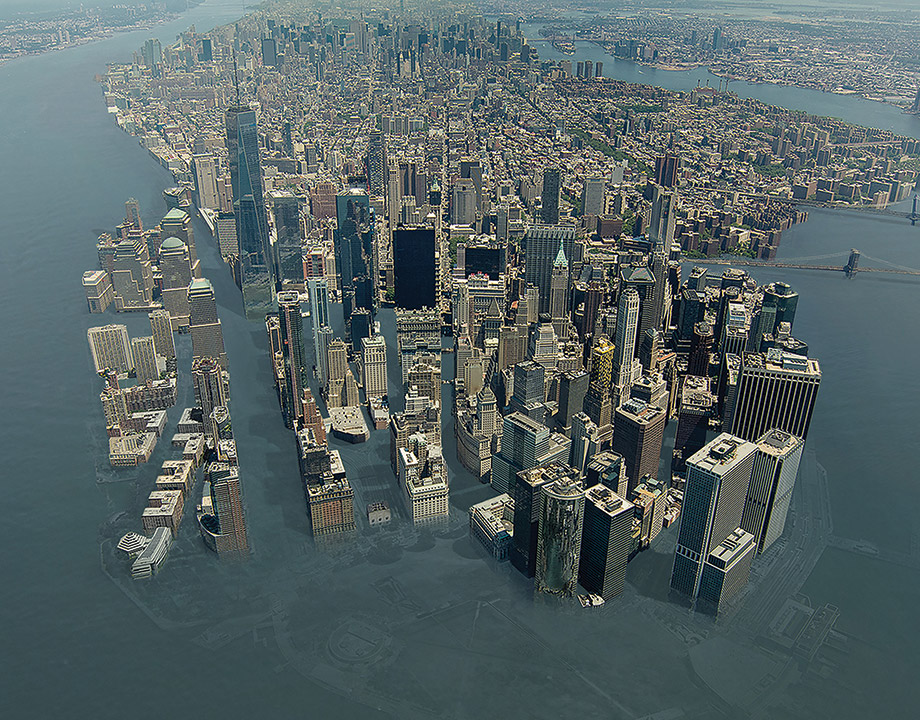
Engineers are looking for solutions to protect critical infrastructure from rising sea levels, before it is too late.
When the Turkey Point Nuclear Generating Station was designed in the 1960s, its site was close to ideal. It was to be situated near a nature preserve 25 miles from Miami, far enough away from population centers not to alarm the neighbors, but close to millions of customers. What’s more, because it was situated on Biscayne Bay, the plant would have access to a virtually limitless supply of cooling water drawn from canals linked to the ocean.
In the intervening 50 years, the situation has changed. For one, the persistent sprawl of greater Miami has brought more than 160,000 residents to the once-rural area near the plant, complicating evacuation plans. More critically, the plant is in danger of being permanently flooded. Built pretty much right at sea level circa 1972, by mid-century the Turkey Point site will be below the high tide line.
What was once a clever design feature for the 1,604 MW nuclear plant is now a liability.
Since the beginning of civilization, humans have built important infrastructure next to the sea, taking advantage of the access to ocean-going transportation. Many of the world’s largest cities are near the ocean, and more than 600 million people live within 10 meters of sea level.
A lot of hard-to-replace infrastructure—ports, power plants, transmission lines, oil refineries, sewage treatment facilities, telecommunications cables, and highways—have been built close to the water. As glaciers melt and warmed waters expand in volume, that infrastructure will be threatened.
In the face of this relentless tide, engineers are looking at what can be done. Can critical infrastructure be hardened or surrounded by high enough sea walls to preserve their function? Or will facilities need to be moved, and existing sites abandoned to the sea?
The tides come in and the tides go out, which as an observation is as beside the point as repeating that the climate is always changing. Local sea level has changed for millennia as some of the land that was crushed by continent-size glaciers 20,000 years ago rebounds and rises, while other areas slowly subside and succumb to the ocean.
Near Bothnian Bay in northern Finland, one-time piers and boathouses lie stranded, while the ruins of the ancient Egyptian port of Heracleion can only be visited by scuba divers.
Further Reading: The Floating City
Apart from those local trends, though, global sea level had been fairly stable for several thousand years, reflecting an equilibrium reached after the end of the last ice age. In the 20th century, though, that equilibrium was disrupted, and sea level began to rise again. A 2018 study led by Steve Nerem of the University of Colorado at Boulder found that this new pulse of sea level rise was accelerating at 0.084 mm per year each year.
“For sea level, the rate in 2005 was about 2.9 mm per year,” Nerem said. “Every year, you add 0.084 mm to the rate.”
That small acceleration adds up over time. The 2.9 mm per year of rise in 2005 becomes 2.984 mm per year in 2006, 4.58 mm per year in 2025, and if the trend continues, 6.68 mm per year by 2050.
That steadily increasing drip doesn’t take into account catastrophic collapses of glaciers in Antarctica and Greenland, which could add not just millimeters, but inches or feet to sea level.
Already, low-lying areas are seeing increasingly frequent flooding, even on sunny days. For instance, thanks to the combination of sea level rise (SLR) and land subsidence, the Louisiana Universities Marine Consortium’s Marine Center, a coastal research institute based in Cocodrie, has seen its parking lot flooded just about any time there’s a southern wind; 20 years ago, that sort of flooding only happened during hurricanes.
A February 2019 study in the journal Science found that high-tide flooding in Annapolis, Md., led to the loss of nearly 3,000 visitors to the City Dock, a downtown tourist attraction, in 2017 alone. “With one foot of additional sea level rise, City Dock would lose 37,506 more visits (28,098 to 45,559) due to high-tide flooding,” the study reported. “This is equivalent to a 24 percent decrease relative to a year with no floods.”
Aggregating the costs over the entire country, researchers Sverre LeRoy and Richard Wiles claim the bill for defending coastal communities from sea-level rise over the next 20 years will be greater than $400 billion.
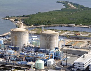 Florida's Turkey Point nuclear plant, which sits right at sea level, will be threatened in the coming decades. Photo: Florida Power & Light
“This is approaching the cost of the original interstate highway system,” they wrote in their June 2019 report, High Tide Tax: The Price to Protect Coastal Communities from Rising Seas, “and will require the construction of more than 50,000 miles of coastal barriers in 22 states in half the time it took to create the nation’s iconic roadway network.” More than $180 billion of the estimated costs are allocated to defending just four low-lying states—Florida, Louisiana, North Carolina, and Virginia—by building thousands of miles of sea wall.
Florida's Turkey Point nuclear plant, which sits right at sea level, will be threatened in the coming decades. Photo: Florida Power & Light
“This is approaching the cost of the original interstate highway system,” they wrote in their June 2019 report, High Tide Tax: The Price to Protect Coastal Communities from Rising Seas, “and will require the construction of more than 50,000 miles of coastal barriers in 22 states in half the time it took to create the nation’s iconic roadway network.” More than $180 billion of the estimated costs are allocated to defending just four low-lying states—Florida, Louisiana, North Carolina, and Virginia—by building thousands of miles of sea wall.
It should be noted that sea level rise won’t have universally bad effects. For example, it is actually beneficial for the Houston Ship Channel’s navigation channel depth, according to Coraggio K. Maglio, chief of the U.S. Army Corps of Engineers’ Hydraulics and Hydrology Branch.
USACE, which is in charge of the ship channel, has estimated the relative sea level rise, which includes both the subsidence and sea level rise using different rates of future sea level change. Using a low level of rise, the 50-year design life channel depth will increase an additional 1.70 feet above the 2023 level. The 100-year planning life channel depth will rise 2.75 feet above the 2023 level. That means larger ships will be able to access facilities along the waterway.
Further Reading: Can Engineering Change Our Climate for the Better?
It’s not all good for the ship channel, though. “Relative sea level rise effects on the associated waterfront infrastructure will largely be detrimental,” Maglio said. “If the high curve rates are realized, significant impacts will occur.”
Some of that impact is because global mean sea level rise adds to transient effects, such as hurricane storm surges or tsunamis, to give natural disasters even more destructive reach. For a city like Houston, which has been hit by two major hurricanes in the past 10 years, these transient effects are especially worrisome.
The Big Disconnect
Docks and ports are obviously at risk, but one surprising bit of infrastructure that’s vulnerable to sea level rise is the internet. Large parts of the worldwide communications system are located underwater—in the form of ocean-spanning submarine cables. Yet, those cables connect to stations on shore and those nodes, and the fiber-optic cables radiating from them are not so robust.
According to a 2018 paper by Paul Barford and Carol Barford, both of the University of Wisconsin, Madison, and Ramakrishnan Durairajan of the University of Oregon, 1,101 nodes and more than 3,500 miles of fiber-optic cable in the United States will either be underwater or completely surrounded by 2033.
“We did not address how sea water would impact the cable,” Paul Barford said. “However, when water permeates anything electrical, the electricity will not work. Once it’s underwater, there is a high probability that the infrastructure will stop working.”
That vulnerability makes sense when the geography of the internet is considered. The network was originally designed to be a robust, almost apocalypse-proof communications conduit, but over time the companies that turned that conduit into content and services migrated to coastal cities such as Seattle, San Francisco, and New York.
The researchers looked at the combination of internet infrastructure density and vulnerability to sea level rise and found that the New York, Miami, and Seattle metropolitan areas were at risk not just of limited outages, but of losing internet connectivity altogether.
For instance, the New York region has 97 nodes and 337 miles of local fiber optic cable at risk from sea level rise. In Seattle, 23.6 percent of the fiber optic cables connecting the metropolitan area to the world will be compromised. The team also found that CenturyLink, Inteliquent, and AT&T are at the highest risk for individual service provider infrastructures.
Further Reading: Blockchain Enables New Power Market
When asked what effects sea level rise will have on the internet if nothing is done, Barford replied, “We don’t know that yet. I speculate that we’ll see an increasing number of outages, and I speculate that a large number of people will not have access to the internet.”
Such a loss of connectivity affects more than Facebook status updates. “If lots of people and businesses lose access to the internet, the results can range from a nuisance to potentially devastating effects,” he said. “Businesses and medical organizations could be affected. We want to make intelligent and informed decisions, which is why we continue to study the problem. If nothing is done, we’ll likely see more outages.”
As sea level rises, it’s unlikely that nothing will be done. But revamping the existing infrastructure—with options ranging from building sea walls around data centers and replacing vulnerable cables with more robust ones to relocating critical operations away from the coast—will entail costs that most companies don’t want to foot.
Particular Vulnerabilities
When Hurricane Sandy hit New York City in 2012, flooding knocked out power to more than 2 million customers and caused an explosion at an electrical substation located along the East River in Manhattan. That damage was a surprise, due to the much higher than expected storm surge, but in the coming decades, power infrastructure in New York and other coastal cities will come under increasing threat of inundation.
According to a 2014 Department of Energy study, the New York metropolitan statistical area (MSA) is “an asset-rich environment vulnerable to SLR because of its topography, location, and concentration of power generation facilities, substations, and petroleum terminals. The MSA, particularly New York City, has a number of assets in low lying areas that are susceptible to inundation from SLR.”
Likewise, in the Houston area, oil refineries and liquefied natural gas terminals will start to be affected at between 2 and 5 feet of SLR.
The report saw the major risk not coming directly from sea level rise. Instead, the higher tides will “isolate assets, impairing their functionality and increasing their exposure to storm surge threats.”
Another study, this one published in 2015 by staffers at the DOE and Oak Ridge National Laboratory, also looked at the interaction of storm surge and sea level rise on the potential of flooding of energy infrastructure. It found that petroleum industry facilities were particularly at risk.
“Roughly 8 percent of U.S. oil refining capacity and 100 percent of strategic petroleum reserve storage capacity are exposed to storm surge caused by the largest hurricanes,” James Bradbury, Melissa Allen, and Rebecca Dell wrote. “This can be explained by the relative high concentration of petroleum infrastructure in the U.S. Gulf Coast region, and their co-location with shipping and port facilities with direct access, and therefore exposure, to the Gulf.”
Although the oil industry is particularly vulnerable, the electric power industry has some potentially large risks. For instance, the storm surge from Hurricane Sandy caused two New Jersey nuclear plants, Salem and Oyster Creek, to shut down due to threats to the plants’ water intake and circulation systems. Those two plants and others, such as Turkey Point in Florida, will be
threatened as sea level continues to rise.
Further Reading: Offshoring Nuclear Plants
“The Fukushima disaster in Japan is a reminder that heightened coastal risk means heightened risk for nuclear plants that are sited near coastlines,” said Michael Mann, director of the Earth System Science Center at Pennsylvania State University. “There is no question that sea level rise, combined with more intense hurricanes, represents increased coastal risk.”
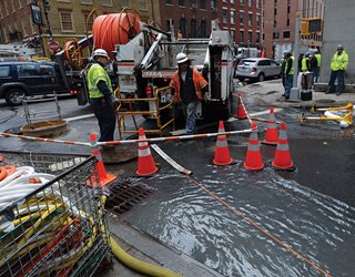 Work crews are pumping water from access tunnels after the storm surge from Hurricane Sandy knocked out underground internet cables in Manhattan. Photo: Getty
“Flooding can disable the backup power supplies and other safety equipment needed to keep the hot and highly radioactive reactor cores and spent nuclear fuel pools from overheating and melting down,” said Edwin Lyman, a physicist who is acting director for the Nuclear Safety Project at the Union of Concerned Scientists. “It can also disable the electrical distribution systems needed to deliver electricity through the plant. If flooding disables backup power supplies, then some equipment needed to cool the reactor and spent fuel, such as electrically powered pumps, would not be available.”
Work crews are pumping water from access tunnels after the storm surge from Hurricane Sandy knocked out underground internet cables in Manhattan. Photo: Getty
“Flooding can disable the backup power supplies and other safety equipment needed to keep the hot and highly radioactive reactor cores and spent nuclear fuel pools from overheating and melting down,” said Edwin Lyman, a physicist who is acting director for the Nuclear Safety Project at the Union of Concerned Scientists. “It can also disable the electrical distribution systems needed to deliver electricity through the plant. If flooding disables backup power supplies, then some equipment needed to cool the reactor and spent fuel, such as electrically powered pumps, would not be available.”
Reevaluating the Hazard
Plant operators have to assess not only the overall potential for flooding, including an estimate of the probable maximum water level the site might face, but also make sure that their plants’ critical safety and support systems can function in the face of such a flood. Barriers and storm drains should have the capacity to prevent floods from inundating buildings containing critical safety equipment.
Even keeping equipment high and dry might not be enough. “At some plants, flooding can impact site access, even if it doesn’t imperil safety equipment,” Lyman said. “This happened recently at the Brunswick plant in North Carolina during Hurricane Florence. This could affect the health and safety of personnel, which could also have an impact on plant safety.”
As it relates to nuclear power plants, however, flooding caused by sea level rise is largely shrugged off by the Nuclear Regulatory Commission (NRC) because of the efforts required of nuclear power plants by the NRC to prevent flooding.
“All U.S. nuclear power plants’ structures, systems, and components important to safety must be designed, built, and maintained so they can continue performing their functions after the effects of site-specific natural phenomena such as flooding,” said Scott Burnell, a spokesperson for the NRC.
“All US nuclear power plants have appropriate site-specific flood protection features based on analysis of potential severe weather events,” Burnell continued. “All U.S. nuclear power plants have conducted updated analyses of flooding hazards (including accounting for potential sea rise effects) as part of the lessons-learned effort following the Fukushima Daiichi accident. All U.S. nuclear power plants have additional resources and procedures to maintain key safety functions if a severe event somehow disables installed systems. These factors mean every coastal U.S. nuclear power plant has shown it can continue operation safely, as well as shut down safely, in the event of site flooding from any source.”
You May Also Like this Video: Nuclear Power: Safety and Reliability
Lyman is concerned that the NRC is not anticipating the quickly changing flood risk. “Nuclear plants in the U.S. are required to have measures to prevent flooding. The problem is that the measures were largely designed to protect against the flooding threats that were estimated when the plants were licensed, many decades ago,” Lyman said. “Site reevaluations after Fukushima found that nearly all U.S. nuclear plants face greater flooding hazards than those they were originally designed to protect against.”
Sea level rise is also happening slowly enough that the NRC believes plants will have ample time to appropriately analyze and address possible future effects, according to Burnell. Indeed, the likelihood is that existing plants will be retired before sea level rise creates a crisis for them.
On the other hand, coastal flooding events from hurricanes have increased over the past two decades, and as sea level rises, these storms will have the potential to reach further and inundate more critical infrastructure than ever before. That means engineers need to consider risks based not just on past experience but also protecting against some of the worst case scenarios.
Some infrastructure can be surrounded by walls and barriers. Others can be hardened to survive temporary inundation. When new infrastructure needs to be built, however, future sea level will likely be a consideration.
Bridget Mintz Testa is a science and technology writer based in Houston, Tex.
In the intervening 50 years, the situation has changed. For one, the persistent sprawl of greater Miami has brought more than 160,000 residents to the once-rural area near the plant, complicating evacuation plans. More critically, the plant is in danger of being permanently flooded. Built pretty much right at sea level circa 1972, by mid-century the Turkey Point site will be below the high tide line.
What was once a clever design feature for the 1,604 MW nuclear plant is now a liability.
Since the beginning of civilization, humans have built important infrastructure next to the sea, taking advantage of the access to ocean-going transportation. Many of the world’s largest cities are near the ocean, and more than 600 million people live within 10 meters of sea level.
A lot of hard-to-replace infrastructure—ports, power plants, transmission lines, oil refineries, sewage treatment facilities, telecommunications cables, and highways—have been built close to the water. As glaciers melt and warmed waters expand in volume, that infrastructure will be threatened.
In the face of this relentless tide, engineers are looking at what can be done. Can critical infrastructure be hardened or surrounded by high enough sea walls to preserve their function? Or will facilities need to be moved, and existing sites abandoned to the sea?
The tides come in and the tides go out, which as an observation is as beside the point as repeating that the climate is always changing. Local sea level has changed for millennia as some of the land that was crushed by continent-size glaciers 20,000 years ago rebounds and rises, while other areas slowly subside and succumb to the ocean.
Near Bothnian Bay in northern Finland, one-time piers and boathouses lie stranded, while the ruins of the ancient Egyptian port of Heracleion can only be visited by scuba divers.
Further Reading: The Floating City
Apart from those local trends, though, global sea level had been fairly stable for several thousand years, reflecting an equilibrium reached after the end of the last ice age. In the 20th century, though, that equilibrium was disrupted, and sea level began to rise again. A 2018 study led by Steve Nerem of the University of Colorado at Boulder found that this new pulse of sea level rise was accelerating at 0.084 mm per year each year.
“For sea level, the rate in 2005 was about 2.9 mm per year,” Nerem said. “Every year, you add 0.084 mm to the rate.”
That small acceleration adds up over time. The 2.9 mm per year of rise in 2005 becomes 2.984 mm per year in 2006, 4.58 mm per year in 2025, and if the trend continues, 6.68 mm per year by 2050.
That steadily increasing drip doesn’t take into account catastrophic collapses of glaciers in Antarctica and Greenland, which could add not just millimeters, but inches or feet to sea level.
Already, low-lying areas are seeing increasingly frequent flooding, even on sunny days. For instance, thanks to the combination of sea level rise (SLR) and land subsidence, the Louisiana Universities Marine Consortium’s Marine Center, a coastal research institute based in Cocodrie, has seen its parking lot flooded just about any time there’s a southern wind; 20 years ago, that sort of flooding only happened during hurricanes.
A February 2019 study in the journal Science found that high-tide flooding in Annapolis, Md., led to the loss of nearly 3,000 visitors to the City Dock, a downtown tourist attraction, in 2017 alone. “With one foot of additional sea level rise, City Dock would lose 37,506 more visits (28,098 to 45,559) due to high-tide flooding,” the study reported. “This is equivalent to a 24 percent decrease relative to a year with no floods.”
Aggregating the costs over the entire country, researchers Sverre LeRoy and Richard Wiles claim the bill for defending coastal communities from sea-level rise over the next 20 years will be greater than $400 billion.
Florida's Turkey Point nuclear plant, which sits right at sea level, will be threatened in the coming decades. Photo: Florida Power & Light
It should be noted that sea level rise won’t have universally bad effects. For example, it is actually beneficial for the Houston Ship Channel’s navigation channel depth, according to Coraggio K. Maglio, chief of the U.S. Army Corps of Engineers’ Hydraulics and Hydrology Branch.
USACE, which is in charge of the ship channel, has estimated the relative sea level rise, which includes both the subsidence and sea level rise using different rates of future sea level change. Using a low level of rise, the 50-year design life channel depth will increase an additional 1.70 feet above the 2023 level. The 100-year planning life channel depth will rise 2.75 feet above the 2023 level. That means larger ships will be able to access facilities along the waterway.
Further Reading: Can Engineering Change Our Climate for the Better?
It’s not all good for the ship channel, though. “Relative sea level rise effects on the associated waterfront infrastructure will largely be detrimental,” Maglio said. “If the high curve rates are realized, significant impacts will occur.”
Some of that impact is because global mean sea level rise adds to transient effects, such as hurricane storm surges or tsunamis, to give natural disasters even more destructive reach. For a city like Houston, which has been hit by two major hurricanes in the past 10 years, these transient effects are especially worrisome.
The Big Disconnect
Docks and ports are obviously at risk, but one surprising bit of infrastructure that’s vulnerable to sea level rise is the internet. Large parts of the worldwide communications system are located underwater—in the form of ocean-spanning submarine cables. Yet, those cables connect to stations on shore and those nodes, and the fiber-optic cables radiating from them are not so robust.
According to a 2018 paper by Paul Barford and Carol Barford, both of the University of Wisconsin, Madison, and Ramakrishnan Durairajan of the University of Oregon, 1,101 nodes and more than 3,500 miles of fiber-optic cable in the United States will either be underwater or completely surrounded by 2033.
“We did not address how sea water would impact the cable,” Paul Barford said. “However, when water permeates anything electrical, the electricity will not work. Once it’s underwater, there is a high probability that the infrastructure will stop working.”
That vulnerability makes sense when the geography of the internet is considered. The network was originally designed to be a robust, almost apocalypse-proof communications conduit, but over time the companies that turned that conduit into content and services migrated to coastal cities such as Seattle, San Francisco, and New York.
The researchers looked at the combination of internet infrastructure density and vulnerability to sea level rise and found that the New York, Miami, and Seattle metropolitan areas were at risk not just of limited outages, but of losing internet connectivity altogether.
For instance, the New York region has 97 nodes and 337 miles of local fiber optic cable at risk from sea level rise. In Seattle, 23.6 percent of the fiber optic cables connecting the metropolitan area to the world will be compromised. The team also found that CenturyLink, Inteliquent, and AT&T are at the highest risk for individual service provider infrastructures.
Further Reading: Blockchain Enables New Power Market
When asked what effects sea level rise will have on the internet if nothing is done, Barford replied, “We don’t know that yet. I speculate that we’ll see an increasing number of outages, and I speculate that a large number of people will not have access to the internet.”
Such a loss of connectivity affects more than Facebook status updates. “If lots of people and businesses lose access to the internet, the results can range from a nuisance to potentially devastating effects,” he said. “Businesses and medical organizations could be affected. We want to make intelligent and informed decisions, which is why we continue to study the problem. If nothing is done, we’ll likely see more outages.”
As sea level rises, it’s unlikely that nothing will be done. But revamping the existing infrastructure—with options ranging from building sea walls around data centers and replacing vulnerable cables with more robust ones to relocating critical operations away from the coast—will entail costs that most companies don’t want to foot.
Particular Vulnerabilities
When Hurricane Sandy hit New York City in 2012, flooding knocked out power to more than 2 million customers and caused an explosion at an electrical substation located along the East River in Manhattan. That damage was a surprise, due to the much higher than expected storm surge, but in the coming decades, power infrastructure in New York and other coastal cities will come under increasing threat of inundation.
According to a 2014 Department of Energy study, the New York metropolitan statistical area (MSA) is “an asset-rich environment vulnerable to SLR because of its topography, location, and concentration of power generation facilities, substations, and petroleum terminals. The MSA, particularly New York City, has a number of assets in low lying areas that are susceptible to inundation from SLR.”
Likewise, in the Houston area, oil refineries and liquefied natural gas terminals will start to be affected at between 2 and 5 feet of SLR.
The report saw the major risk not coming directly from sea level rise. Instead, the higher tides will “isolate assets, impairing their functionality and increasing their exposure to storm surge threats.”
Another study, this one published in 2015 by staffers at the DOE and Oak Ridge National Laboratory, also looked at the interaction of storm surge and sea level rise on the potential of flooding of energy infrastructure. It found that petroleum industry facilities were particularly at risk.
“Roughly 8 percent of U.S. oil refining capacity and 100 percent of strategic petroleum reserve storage capacity are exposed to storm surge caused by the largest hurricanes,” James Bradbury, Melissa Allen, and Rebecca Dell wrote. “This can be explained by the relative high concentration of petroleum infrastructure in the U.S. Gulf Coast region, and their co-location with shipping and port facilities with direct access, and therefore exposure, to the Gulf.”
Although the oil industry is particularly vulnerable, the electric power industry has some potentially large risks. For instance, the storm surge from Hurricane Sandy caused two New Jersey nuclear plants, Salem and Oyster Creek, to shut down due to threats to the plants’ water intake and circulation systems. Those two plants and others, such as Turkey Point in Florida, will be
threatened as sea level continues to rise.
Further Reading: Offshoring Nuclear Plants
“The Fukushima disaster in Japan is a reminder that heightened coastal risk means heightened risk for nuclear plants that are sited near coastlines,” said Michael Mann, director of the Earth System Science Center at Pennsylvania State University. “There is no question that sea level rise, combined with more intense hurricanes, represents increased coastal risk.”
Work crews are pumping water from access tunnels after the storm surge from Hurricane Sandy knocked out underground internet cables in Manhattan. Photo: Getty
Reevaluating the Hazard
Plant operators have to assess not only the overall potential for flooding, including an estimate of the probable maximum water level the site might face, but also make sure that their plants’ critical safety and support systems can function in the face of such a flood. Barriers and storm drains should have the capacity to prevent floods from inundating buildings containing critical safety equipment.
Even keeping equipment high and dry might not be enough. “At some plants, flooding can impact site access, even if it doesn’t imperil safety equipment,” Lyman said. “This happened recently at the Brunswick plant in North Carolina during Hurricane Florence. This could affect the health and safety of personnel, which could also have an impact on plant safety.”
As it relates to nuclear power plants, however, flooding caused by sea level rise is largely shrugged off by the Nuclear Regulatory Commission (NRC) because of the efforts required of nuclear power plants by the NRC to prevent flooding.
“All U.S. nuclear power plants’ structures, systems, and components important to safety must be designed, built, and maintained so they can continue performing their functions after the effects of site-specific natural phenomena such as flooding,” said Scott Burnell, a spokesperson for the NRC.
“All US nuclear power plants have appropriate site-specific flood protection features based on analysis of potential severe weather events,” Burnell continued. “All U.S. nuclear power plants have conducted updated analyses of flooding hazards (including accounting for potential sea rise effects) as part of the lessons-learned effort following the Fukushima Daiichi accident. All U.S. nuclear power plants have additional resources and procedures to maintain key safety functions if a severe event somehow disables installed systems. These factors mean every coastal U.S. nuclear power plant has shown it can continue operation safely, as well as shut down safely, in the event of site flooding from any source.”
You May Also Like this Video: Nuclear Power: Safety and Reliability
Lyman is concerned that the NRC is not anticipating the quickly changing flood risk. “Nuclear plants in the U.S. are required to have measures to prevent flooding. The problem is that the measures were largely designed to protect against the flooding threats that were estimated when the plants were licensed, many decades ago,” Lyman said. “Site reevaluations after Fukushima found that nearly all U.S. nuclear plants face greater flooding hazards than those they were originally designed to protect against.”
Sea level rise is also happening slowly enough that the NRC believes plants will have ample time to appropriately analyze and address possible future effects, according to Burnell. Indeed, the likelihood is that existing plants will be retired before sea level rise creates a crisis for them.
On the other hand, coastal flooding events from hurricanes have increased over the past two decades, and as sea level rises, these storms will have the potential to reach further and inundate more critical infrastructure than ever before. That means engineers need to consider risks based not just on past experience but also protecting against some of the worst case scenarios.
Some infrastructure can be surrounded by walls and barriers. Others can be hardened to survive temporary inundation. When new infrastructure needs to be built, however, future sea level will likely be a consideration.
Bridget Mintz Testa is a science and technology writer based in Houston, Tex.
Related Content

Energy Blog: Noticeable Eclipse Impact on Electricity Sector
Apr 17, 2024

Fulfilling a Dream: The Late-in-Life Ph.D.
Apr 16, 2024
The trend of pursuing a Ph.D. later in life is real. But there are challenges for students who decide to return to the classroom and pursue an advanced degree.

Breakthrough Could Make for Long-Range EVs
Apr 16, 2024
A simple method could lead to electric vehicles that can go much father on a single charge, and batteries that last years longer than present technology.

Workforce Blog: We Need to Reimagine Workforce 4.0
Apr 3, 2024
ASME is supporting new strategies to diversify and expand the talent pool.